Restaurant nearby Essaraya
Tunisia
Restaurant nearby Essaraya
Essaraya
Souks, Tunis, Tunesien
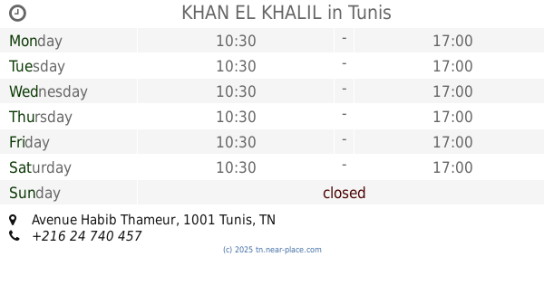
contacts phone
:
+216
Latitude:
36.8001813
, Longitude:
10.1695925
larger map & directions
read more
nearest Restaurant
118 m
ملاوي شباطي نور
Rue Sidi Sridek, Tunis
Restaurant
read more
136 m
Fast Food Nour
El Hafsia, Tunis
Restaurant
read more
142 m
La Bonne Bouffe
El Hafsia, Tunis
Restaurant
read more
177 m
Diwan Dar El Jeld
Souks, Tunis
Restaurant
read more
185 m
Dar El Jeld
Tunis
Restaurant
read more
318 m
Fondouk El Attarine
Souk Attarine, Tunis
Restaurant
read more
329 m
El Marbet
27,, Souk Trok, Tunis
Restaurant
read more
430 m
chateau de la medina
Souks, Tunis
Restaurant
read more
449 m
Restaurant El Abed
Souks, Tunis
Restaurant
read more
469 m
Restaurant Aswek
Tunis
Restaurant
read more
473 m
Kafteji Faouzi
Rue Tourbet El Bey, Tunis
Restaurant
read more
476 m
Restaurant Essaraya
6 Rue Ben Mahmoud Boulevard Bab Menara, Tunis
Restaurant
read more
491 m
Fast Food Chez Sami
Rue Tourbet El Bey, Tunis
Restaurant
read more
522 m
Dar Al-Hussein
Rue du Château, Tunis
Restaurant
read more
839 m
Apollo11
110 Avenue de Londres, Tunis
Restaurant
read more
879 m
Chez Jalel (Pla Tunisien Fromag
16, Rue Habib Chatti, jewahdou
Restaurant
read more
885 m
L'Entracte Café - Restaurant
Rue d'Alger, Tunis
Restaurant
read more
889 m
Le petit Tunis
6, Rue d'Alger, Tunis
Restaurant
read more
944 m
Restaurant le Parnasse
Avenue Habib Bourguiba, Tunis
Restaurant
read more
964 m
L'event
Rue Ali Bach Hamba, Tunis
Restaurant
read more
1.087 km
KHAN EL KHALIL
Avenue Habib Thameur, Tunis
Restaurant
read more
1.144 km
Restaurant La Mamma
Rue de Marseille, Tunis
Restaurant
read more
1.191 km
Queen's Fast Food
Rue Mokhtar Attia, Tunis
Restaurant
read more
1.196 km
مطعم الصفاقسي
Rue du Caire, Tunis
Restaurant
read more
1.274 km
le petit etoile
sidi ali mekki nijila، ghar el milh sidi ali al mekki
Restaurant
read more
📑
all categories
Accounting
Administrative area level 1
Administrative area level 2
Airport
Amusement park
Aquarium
Art gallery
Atm
Bakery
Bank
Bar
Beauty salon
Bicycle store
Book store
Bowling alley
Bus station
Cafe
Campground
Car dealer
Car rental
Car repair
Car wash
Casino
Cemetery
Church
City hall
Clothing store
Convenience store
Courthouse
Dentist
Department store
Doctor
Electrician
Electronics store
Embassy
Establishment
Finance
Fire station
Florist
Food
Furniture store
Gas station
General contractor
Grocery or supermarket
Gym
Hair care
Hardware store
Health
Home goods store
Hospital
Insurance agency
Jewelry store
Laundry
Lawyer
Library
Liquor store
Local government office
Locality
Locksmith
Lodging
Meal delivery
Meal takeaway
Mosque
Movie rental
Movie theater
Moving company
Museum
Natural feature
Neighborhood
Night club
Painter
Park
Parking
Pet store
Pharmacy
Physiotherapist
Place of worship
Plumber
Point of interest
Police
Post office
Premise
Real estate agency
Restaurant
Roofing contractor
Route
School
Shoe store
Shopping mall
Spa
Stadium
Storage
Store
Subway station
Supermarket
Synagogue
Taxi stand
Train station
Transit station
Travel agency
University
Veterinary care
Zoo
sublocality level 1
↑